
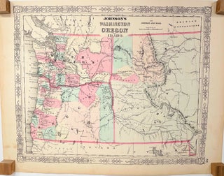
Johnson's Washington, Oregon and Idaho; [1863 Johnson's New Illustrated (Steel Plate) Family Atlas, Plate 57]
New York: Johnson and Ward, 1863. Very Good. 2nd State. [15.5x12.75in neatline and borders, 18x14in sheet]; Partial colored map of Washington and Oregon Territories and Idaho, with parts of California, Nevada, Utah, and British Possessions, details counties in Washington and Oregon, communities, forts, trails, Native American tribal areas, rivers and..... Item #14018