![Item #13565 Sketch of Portlocks & Gouldings Harbour's on the North West Coast of America; Variation 25 00' E [from the 1789, A Voyage Round the World; But More Particularly to the North-West Coast of America: Performed in 1785, 1786, 1787, and 1788 with George Dixon]. Nathaniel Portlock.](https://davidspilmanfinebooks.cdn.bibliopolis.com/pictures/13565.jpg?width=768&height=1000&fit=bounds&auto=webp&v=1556497453)
![Sketch of Portlocks & Gouldings Harbour's on the North West Coast of America; Variation 25 00' E [from the 1789, A Voyage Round the World; But More Particularly to the North-West Coast of America: Performed in 1785, 1786, 1787, and 1788 with George Dixon]](https://davidspilmanfinebooks.cdn.bibliopolis.com/pictures/13565_1.jpg?auto=webp&v=1556497453)
![Sketch of Portlocks & Gouldings Harbour's on the North West Coast of America; Variation 25 00' E [from the 1789, A Voyage Round the World; But More Particularly to the North-West Coast of America: Performed in 1785, 1786, 1787, and 1788 with George Dixon]](https://davidspilmanfinebooks.cdn.bibliopolis.com/pictures/13565_2.jpg?auto=webp&v=1556497453)
Sketch of Portlocks & Gouldings Harbour's on the North West Coast of America; Variation 25 00' E [from the 1789, A Voyage Round the World; But More Particularly to the North-West Coast of America: Performed in 1785, 1786, 1787, and 1788 with George Dixon]
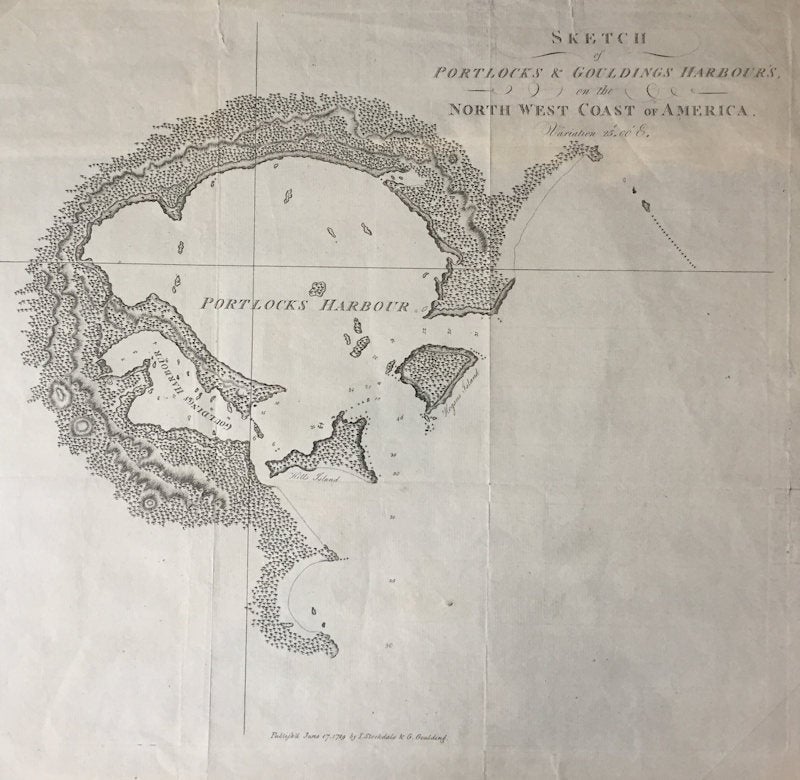
London: I. Stockdale and G. Goulding, 1789. Very Good. First Edition. [13.25x15in to imprint lines, 15.25x16.875in sheet]; Title in upper right corner with June 17, 1789 and publisher in bottom center, faint sculptor name on bottom left, no neat lines or location references, shows Portlocks and Gouldings Harbors with Hills and Hogans Islands, depth soundings reflecting track with anchorage and hazards noted, also drawn are peaks, ridges and forested areas; Minor age toning at edges, edges chipped, issued folding with six panel crease lines. [Wagner Maps 741, Hill 1376, Lada-Mocarski 42]. Item #13565
Nathaniel Portlock (1748-1814) and George Dixon (1748-1795) both serviced with Captain Cook on his third voyage that included the Pacific Northwest. They became partners in the King George's Sound Company in 1775 for fur trading on the northwest coast of America. Portlock's referenced book, issued at the same time as Dixon's, described a three year voyage of the King George (Portlock) and Queen Charlotte (Dixon) ships to the North Pacific Ocean and northwest coast of North America to expand the region's fur trade. During the voyage, the ships were often on separate tracks with some rendezvous and wintering in the Sandwich Islands. Both Portlock's and Dixon's books describe different experiences and discoveries.
The Nootka Sound (also known as King George's Sound) was claimed by Spain and foreign ships were not welcomed. In 1787, Portlock surveyed these harbors as a possible base for the Alaskan Fur trading operations. This Chichagof Island harbor map (north of Sitka and west of Juneau, Alaska) is one of the earliest Alaskan harbor maps.
Price: $190.00