![Item #14123 Tartarie Sive Magni Chami Regni Typus; [Published in Theatrum Orbis Terrarum 1609] [Originally published in 1570]. Abraham Ortelius.](https://davidspilmanfinebooks.cdn.bibliopolis.com/pictures/14123.jpg?width=768&height=1000&fit=bounds&auto=webp&v=1710978336)
![Tartarie Sive Magni Chami Regni Typus; [Published in Theatrum Orbis Terrarum 1609] [Originally published in 1570]](https://davidspilmanfinebooks.cdn.bibliopolis.com/pictures/14123_1.jpg?auto=webp&v=1710978336)
![Tartarie Sive Magni Chami Regni Typus; [Published in Theatrum Orbis Terrarum 1609] [Originally published in 1570]](https://davidspilmanfinebooks.cdn.bibliopolis.com/pictures/14123_2.jpg?auto=webp&v=1710978336)
![Tartarie Sive Magni Chami Regni Typus; [Published in Theatrum Orbis Terrarum 1609] [Originally published in 1570]](https://davidspilmanfinebooks.cdn.bibliopolis.com/pictures/14123_3.jpg?auto=webp&v=1710978336)
![Tartarie Sive Magni Chami Regni Typus; [Published in Theatrum Orbis Terrarum 1609] [Originally published in 1570]](https://davidspilmanfinebooks.cdn.bibliopolis.com/pictures/14123_4.jpg?auto=webp&v=1710978336)
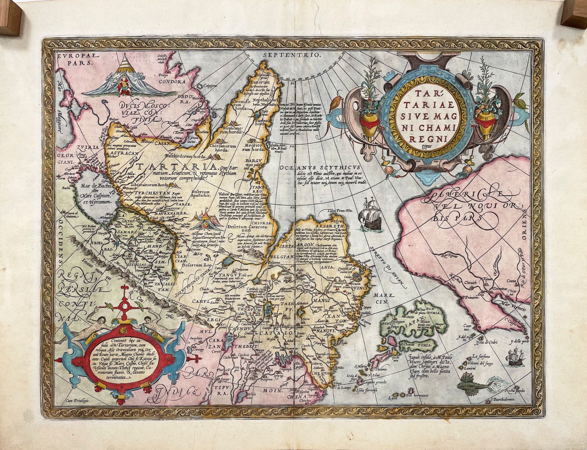
Tartarie Sive Magni Chami Regni Typus; [Published in Theatrum Orbis Terrarum 1609] [Originally published in 1570]
Antwerp: Abraham Ortelius, c. 1609. Very Good. 4th State. [13.5x18.25in, 34.3x46.4cm neat line, 15.5x21.5in, 39.4x54.6cm sheet] Colored and very ornate map of part of Europe, Russia, Siberia, Northwest cost of North America, and Japan, ornate title and narrative cartouche, the map is in Latin with a Dutch narrative on verso with #74 at bottom, single vertical crease, colors vibrant, light age toning and minor soiling on verso. [Burden 41, Van Den Broecke 163, Wagner Northwest 81 (1570), Skelton Plate 60] CS. Item #14123
Abraham Ortelius (1527-1598) was a Dutch cartographer and publisher of the first 'modern style' atlas in 1570, the Theatrum Orbis Terrarum (Theatre of the World). Maps were produced, published and sold individually in different sizes and formats, and then bound in books as selected by the buyer. The Ortelius atlas was published with uniform size, formatting and coloring of the maps, along with narratives on the verso. There were a number of printings between 1570 to 1641, and many of the engraved maps were updated as needed. This map is the fourth state and was published in c.1609 as Plate 74 with a estimated 166 plates. From Van Den Broecke, this map was based on earlier maps by Ortelius and from others. "Apart from showing the Anian (Bering) strait, this map contains no new information." The map is important for the details of rivers and communities in eastern Siberia and the vignettes on land and the sea..
This map was from the library of the late Dr. G. Warren Smith of Pennsylvania. He had a long career as university professor and administrator, and was a collector of over 6,000 books, maps, illustrations, and artifacts relating to the Arctic, Alaska and Pacific Northwest.
Price: $900.00