![Item #13733 Rand McNally & Co.'s Commercial Atlas of America; New Commercial Atlas Map of Alaska [Hawaiian Islands on verso]. Rand McNally, Co.'s.](https://davidspilmanfinebooks.cdn.bibliopolis.com/pictures/13733.jpg?width=768&height=1000&fit=bounds&auto=webp&v=1586836038)
![Rand McNally & Co.'s Commercial Atlas of America; New Commercial Atlas Map of Alaska [Hawaiian Islands on verso]](https://davidspilmanfinebooks.cdn.bibliopolis.com/pictures/13733_1.jpg?auto=webp&v=1586836038)
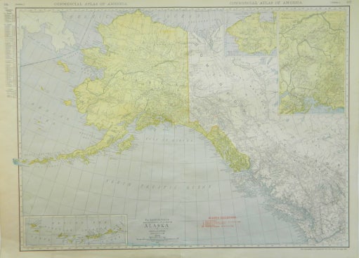
Rand McNally & Co.'s Commercial Atlas of America; New Commercial Atlas Map of Alaska [Hawaiian Islands on verso]
Rand McNally & Company, 1913. Near Fine. Later printing. [Neat line 18.875x25.75in, Sheet 20.5x27.75in]; 335-338 pp., Map of Alaska and British Columbia (44 to 66 N, 120 to 172 W), insets of Mt. McKinley District, Steward Peninsula Mining District and Aleutian Islands, red ink legend of Alaskan Railroads (United Stated government, Copper River & Northwestern, North Pole Route, Solomon River R. R. Co., Tanana Valley and White Pass & Yukon; On verso listing of Districts, features and communities for New Brunswick and Alaska; Slight age toning along edges, horizontal fold. Item #13733
Price: $100.00
See all items in
Adventure
See all items by Rand McNally, Co.'s