![Item #14018 Johnson's Washington, Oregon and Idaho; [1863 Johnson's New Illustrated (Steel Plate) Family Atlas, Plate 57]. A. J. Johnson.](https://davidspilmanfinebooks.cdn.bibliopolis.com/pictures/14018.jpg?width=768&height=1000&fit=bounds&auto=webp&v=1664984266)
![Johnson's Washington, Oregon and Idaho; [1863 Johnson's New Illustrated (Steel Plate) Family Atlas, Plate 57]](https://davidspilmanfinebooks.cdn.bibliopolis.com/pictures/14018_1.jpg?auto=webp&v=1664984266)
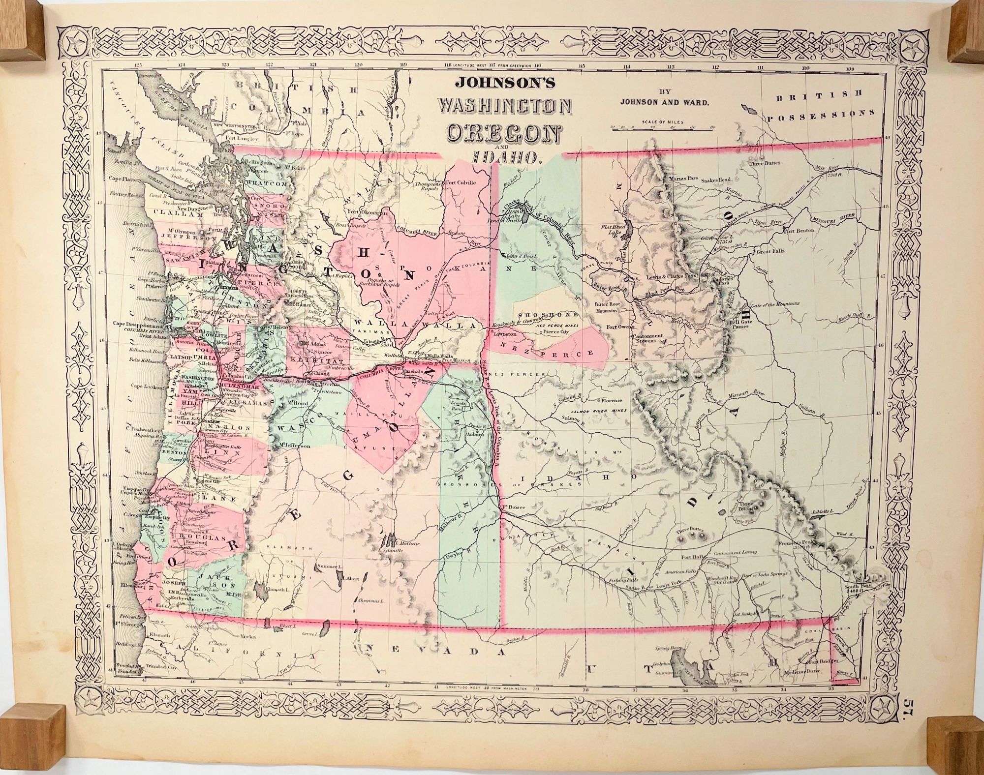
Johnson's Washington, Oregon and Idaho; [1863 Johnson's New Illustrated (Steel Plate) Family Atlas, Plate 57]
New York: Johnson and Ward, 1863. Very Good. 2nd State. [15.5x12.75in neatline and borders, 18x14in sheet]; Partial colored map of Washington and Oregon Territories and Idaho, with parts of California, Nevada, Utah, and British Possessions, details counties in Washington and Oregon, communities, forts, trails, Native American tribal areas, rivers and other geographical features, on verso 'Historical and Statistical View of the United States, 1860 showing Vermont, Virginia, Wisconsin, and Territories of Colorado, Dakota and Nevada; Some age toning along edges with several light stains and soil spots. [Wheat Trans-Miss p. 100, Lourie Map Project]. Item #14018
Alvin Jewett Johnson (1827-1884) was a map publisher that also worked for J. H. Colton, map publishing in the 1850's. During that time, Johnson developed experience, and Ross Browning as a partner, to establish to publish maps and atlases using Colton's steel plates reworked to lithographic stones. In 1860, Johnson issued the Johnson's New Illustrated (Steel Plate) Family Atlas. With the beginning of the American Civil War, Browning remained in Virginia and sold his share to B. P. Ward.
This map was issued in the rare 1863 Johnson's New Illustrated (Steel Plate) Family Atlas, which was a mixed group of early maps from Johnson and Browning, updated 1862 Johnson and Ward and newer 1863 maps with updated with a revised boarder design. The Ira Lourie's Johnson Map Project identifies this map as the second state, with Idaho in the title, that included a revised Washington eastern boundary and part of the Idaho territory. This later 1863 version was issued prior to Idaho formally established as a Territory in March, 1863 with defined borders, and does not identify Montana or Dakota (as seen in the 1864 Atlas, Plate 65).
Price: $250.00