![Item #14041 North America; [A c.1849 map by Rapkin and Tallis] [Published in 'The British Colonies; Their History, Extent, Condition and Resource's, c. 1851]. Tallis Rapkin J., John, Montgomery Martin Esq.](https://davidspilmanfinebooks.cdn.bibliopolis.com/pictures/14041.jpg?width=768&height=1000&fit=bounds&auto=webp&v=1665108750)
![North America; [A c.1849 map by Rapkin and Tallis] [Published in 'The British Colonies; Their History, Extent, Condition and Resource's, c. 1851]](https://davidspilmanfinebooks.cdn.bibliopolis.com/pictures/14041_1.jpg?auto=webp&v=1665108750)
![North America; [A c.1849 map by Rapkin and Tallis] [Published in 'The British Colonies; Their History, Extent, Condition and Resource's, c. 1851]](https://davidspilmanfinebooks.cdn.bibliopolis.com/pictures/14041_2.jpg?auto=webp&v=1665108750)
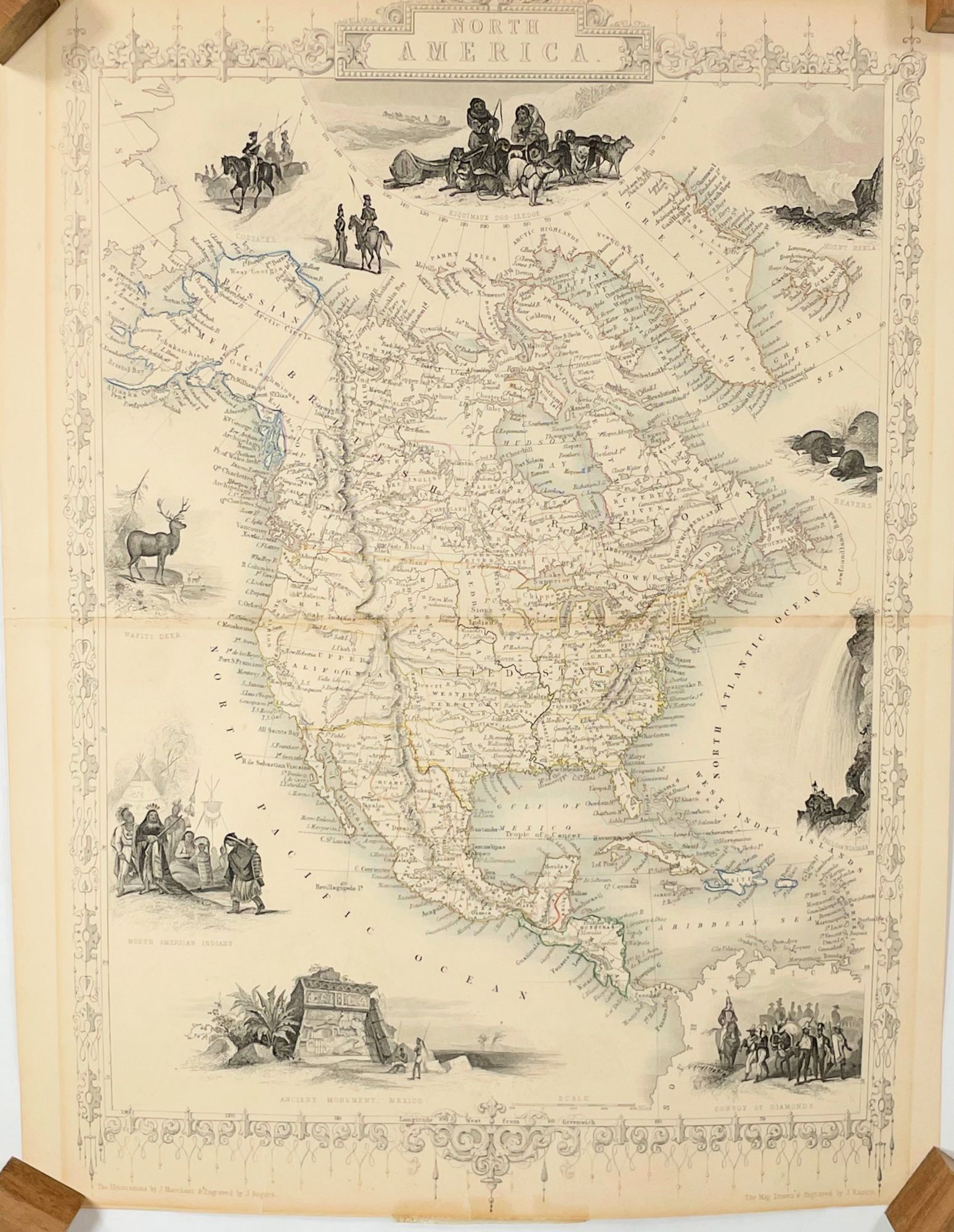
North America; [A c.1849 map by Rapkin and Tallis] [Published in 'The British Colonies; Their History, Extent, Condition and Resource's, c. 1851]
London: The London Printing and Publishing Company, c. 1851. Very Good. First State. [11.875x8.75in neatline, 13.75x10.5in sheet], An outline colored decorative and very detailed map of North America including Central America, part of South America, the Caribbean, Greenland and part of Siberia with geographical and political features; Horizontal centerfold as issued in the Atlas with ornate border, illustrations drawn by J. Marchant and engraved by J. Rogers, map drawn and engraved by J. Rapkin; Some age toning to map with several offset shadows, faint color outlines, top and bottom margins trimmed for publication with loss of border decoration and partial publisher text, two closed tears along bottom edge with old tape shadows and recent archive tape repair. [Rumsey 0466.065] CS. Item #14041
John Tallis (1817-1876) was a British map and atlas publisher in the mid-1800’s. This North American map was in the 'Illustrated World Atlas' which was published for the Great Exhibition of 1851 in London to promote British history, industry and culture. Decorative maps with colored vignettes were popular at time. John Rapkin (1813-1899) was a well known mapmaker and engraver in London for fine detailed maps of cities and countries. He worked with Tallis and other map publishers on atlases and single productions.
This map was published in ‘The British Colonies; the History, Extent, Condition, and Resources’ by Montgomery Martin in c.1851 as part of the promotion of Great Britain and the Exhibition.
The color vignette illustrations were drawn by J. Marchant and engraved by J. Rogers. The ten vignettes are an Esquimaux dog-sledge, Mount Hekla, Beavers, Falls of Niagara, Convoy of Diamonds, Ancient Monument Mexico, North American Indians, Wapiti Deer and Cossacks. In 1851, the United States had 30 States, this map does not show California as a State and does show the Oregon, Missouri, Nebraska and Western territories. Alaska is show as Russian America and most of Canada as British Territory.
This map was from the library of the late Dr. G. Warren Smith of Pennsylvania. He had a long career as university professor and administrator, and was a collector of over 6,000 books, maps, illustrations, and artifacts relating to the Arctic, Alaska and Pacific Northwest.
Price: $250.00