![Item #14043 Arctic Regions showing The North-West Passage; as determined by Cap. R. McClure and other Arctic Voyagers. Compiled by J. Hugh Johnson, F.R.G.S. [The Royal Illustrated Atlas of Modern Geography with an Introductory notice by Dr. N. Shaw, Secretary to the Royal Geographical Society, Plate III.]. A. Fullarton, J. Hugh Johnson.](https://davidspilmanfinebooks.cdn.bibliopolis.com/pictures/14043.jpg?width=768&height=1000&fit=bounds&auto=webp&v=1711747934)
![Arctic Regions showing The North-West Passage; as determined by Cap. R. McClure and other Arctic Voyagers. Compiled by J. Hugh Johnson, F.R.G.S. [The Royal Illustrated Atlas of Modern Geography with an Introductory notice by Dr. N. Shaw, Secretary to the Royal Geographical Society, Plate III.]](https://davidspilmanfinebooks.cdn.bibliopolis.com/pictures/14043_1.jpg?auto=webp&v=1711747935)
![Arctic Regions showing The North-West Passage; as determined by Cap. R. McClure and other Arctic Voyagers. Compiled by J. Hugh Johnson, F.R.G.S. [The Royal Illustrated Atlas of Modern Geography with an Introductory notice by Dr. N. Shaw, Secretary to the Royal Geographical Society, Plate III.]](https://davidspilmanfinebooks.cdn.bibliopolis.com/pictures/14043_2.jpg?auto=webp&v=1711747934)
![Arctic Regions showing The North-West Passage; as determined by Cap. R. McClure and other Arctic Voyagers. Compiled by J. Hugh Johnson, F.R.G.S. [The Royal Illustrated Atlas of Modern Geography with an Introductory notice by Dr. N. Shaw, Secretary to the Royal Geographical Society, Plate III.]](https://davidspilmanfinebooks.cdn.bibliopolis.com/pictures/14043_3.jpg?auto=webp&v=1711747935)
![Arctic Regions showing The North-West Passage; as determined by Cap. R. McClure and other Arctic Voyagers. Compiled by J. Hugh Johnson, F.R.G.S. [The Royal Illustrated Atlas of Modern Geography with an Introductory notice by Dr. N. Shaw, Secretary to the Royal Geographical Society, Plate III.]](https://davidspilmanfinebooks.cdn.bibliopolis.com/pictures/14043_4.jpg?auto=webp&v=1711747935)
![Arctic Regions showing The North-West Passage; as determined by Cap. R. McClure and other Arctic Voyagers. Compiled by J. Hugh Johnson, F.R.G.S. [The Royal Illustrated Atlas of Modern Geography with an Introductory notice by Dr. N. Shaw, Secretary to the Royal Geographical Society, Plate III.]](https://davidspilmanfinebooks.cdn.bibliopolis.com/pictures/14043_5.jpg?auto=webp&v=1711747935)
![Arctic Regions showing The North-West Passage; as determined by Cap. R. McClure and other Arctic Voyagers. Compiled by J. Hugh Johnson, F.R.G.S. [The Royal Illustrated Atlas of Modern Geography with an Introductory notice by Dr. N. Shaw, Secretary to the Royal Geographical Society, Plate III.]](https://davidspilmanfinebooks.cdn.bibliopolis.com/pictures/14043_6.jpg?auto=webp&v=1711747935)
![Arctic Regions showing The North-West Passage; as determined by Cap. R. McClure and other Arctic Voyagers. Compiled by J. Hugh Johnson, F.R.G.S. [The Royal Illustrated Atlas of Modern Geography with an Introductory notice by Dr. N. Shaw, Secretary to the Royal Geographical Society, Plate III.]](https://davidspilmanfinebooks.cdn.bibliopolis.com/pictures/14043_7.jpg?auto=webp&v=1711747935)
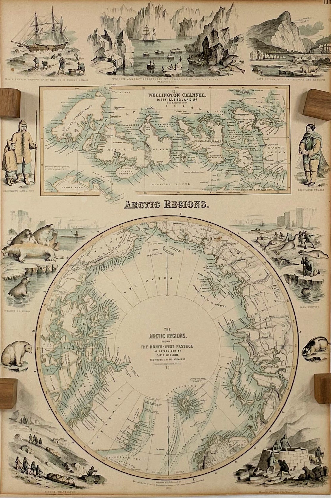
Arctic Regions showing The North-West Passage; as determined by Cap. R. McClure and other Arctic Voyagers. Compiled by J. Hugh Johnson, F.R.G.S. [The Royal Illustrated Atlas of Modern Geography with an Introductory notice by Dr. N. Shaw, Secretary to the Royal Geographical Society, Plate III.]
London: A. Fullarton and Company, 1872. Very Good. Later Edition. [Map dated 1856][18.5x12.5 sheet, no sheet neatline]; Two colored maps - Arctic polar projection to 60 North [9.75in dia.] and detailed inset of Wellington Channel with Melville Island and others [4x9.25in, 74 to 78 N, 90 to 125 W] bordered by eleven colored vignettes from different Arctic journals and expeditions, relief shown by hachures, details ocean currents and direction, route of Northwest passage, geographical names, tundra line, forts and settlements; Some age toning to all edges, bottom edge trimmed with loss of publisher text, small stain bleed from verso at Kolyma river text and upper right vignette, light toning to maps and illustrations, darker colors that on other maps. [Rumsey 3007-003] CS. Item #14043
Archibald Fullarton (1804-1882) was a Glasgow publisher in partnership with John Blackie from 1809. He published several "Royal Illustrated Atlas" editions starting in 1864. This 1856 map was included in the 1872 edition as Plate 111 of the Atlas. Many of the maps were noted for the detailed illustrations and coloring. Also, many of the maps, according to Rumsey, were not updated in the various editions, as typical of other multiple issues of Atlases. This map still shows Alaska as Russian America, which was bought by the United States in 1867.
The eleven vignettes form an illustrated "border" for the two maps. The illustrations are from various sources to wonderfully show the beauty and harshness of the Arctic, the people and animals. The top vignette is the H.M.S. Prince Albert" surrounded by ice bergs in Melville Bay, and watched by seals and birds. Others are, Cape Cape Hotham with the "H.M.S. Pioneer and Resolute", an Esquimaux female, man and boy, seal hunting scene, building a snow hut (from Kennedy's 2nd voyage of the Prince Albert), sledge traveling from Osborne's Arctic Journal, walrus or horse on an ice flow, the "H.M.S. Terror" thrown up by the ice in Prosen Strait, and a polar bear and otter on the ice.
Robert McClure (1807-1873) was a British Royal Navy Captain and Arctic explorer. In 1850, McClure was ordered to command the "H.M.S. Investigator" and explore the North-West passage from the west through the Bering Strait. They were successful in pushing through the coastal ice flows to discover Bank Is and the strait to the Melville Sound, which confirmed the Northwest passage route to the Atlantic ocean.
This map was from the library of the late Dr. G. Warren Smith of Pennsylvania. He had a long career as university professor and administrator, and was a collector of over 6,000 books, maps, illustrations, and artifacts relating to the Arctic, Alaska and Pacific Northwest.
Price: $300.00